Teesdale (distrikt)
Utseende
| Teesdale | |
| Före detta distrikt | |
| Land | |
|---|---|
| Riksdel | England |
| Ceremoniellt grevskap | Durham |
| Enhetskommun | Durham |
| Folkmängd | 24 457 (2001) |
| Tidszon | UTC (UTC+0) |
| - sommartid | BST (UTC+1) |
|
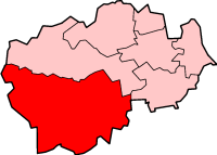
Läge i Durham
| |
Teesdale var mellan 1974 och 2009 ett distrikt i grevskapet Durham, England. Distriktet har 24 457 invånare (2001).[1] År 2009 blev distriktet en del av enhetskommunen Durham.
Civil parishes
[redigera | redigera wikitext]- Barforth, Barnard Castle, Barningham, Bolam, Boldron, Bowes, Brignall, Cleatlam, Cockfield, Cotherstone, Eggleston, Egglestone Abbey, Etherley, Evenwood and Barony, Forest and Frith, Gainford, Gilmonby, Hamsterley, Headlam, Hilton, Holwick, Hope, Hunderthwaite, Hutton Magna, Ingleton, Land common to Hamsterley, Lynesack and Softley and South Bedburn, Langleydale and Shotton, Langton, Lartington, Lunedale, Lynesack and Softley, Marwood, Mickleton, Middleton in Teesdale, Morton Tinmouth, Newbiggin, Ovington, Raby with Keverstone, Rokeby, Romaldkirk, Scargill, South Bedburn, Staindrop, Startforth, Streatlam and Stainton, Wackerfield, Westwick, Whorlton, Winston, Woodland och Wycliffe with Thorpe.[2]
Referenser
[redigera | redigera wikitext]- ^ ONS. ”Area: Teesdale (Former Local Authority)”. Neighbourhood statistics. http://neighbourhood.statistics.gov.uk/dissemination/LeadKeyFigures.do?a=7&b=276947&c=Teesdale&d=13&e=15&g=440870&i=1001x1003x1032x1004&m=0&r=1&s=1475418565555&enc=1. Läst 2 oktober 2016.
- ^ ”Area selected: Teesdale (Non-Metropolitan District)”. Neighbourhood statistics. Arkiverad från originalet den 21 oktober 2016. https://web.archive.org/web/20161021055656/http://www.neighbourhood.statistics.gov.uk/dissemination/viewFullDataset.do?instanceSelection=03070&productId=779&$ph=60_61&datasetInstanceId=3070&startColumn=1&numberOfColumns=4&containerAreaId=790378&nsjs=true&nsck=false&nssvg=false&nswid=1366. Läst 2 oktober 2016.


