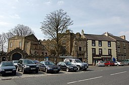
Stanhope, Durham
Utseende
- För andra betydelser, se Stanhope (olika betydelser).
| Stanhope | |
| Land | |
|---|---|
| Riksdel | England |
| Region | Nordöstra England |
| Ceremoniellt grevskap | Durham |
| Enhetskommun | Durham |
| Civil parish | Stanhope |
| Koordinater | 54°44′54″N 2°00′32″V / 54.7484°N 2.0090°V |
| Tidszon | GMT (UTC+0) |
| Riktnummer | 01388 |
| Geonames | 2637078 |
Stanhope är en by och civil parish, i distriktet Durham, i grevskapet Durham i England. Byn hade 1 572 invånare år 2021.[1]
Civil parishen utgörs av orterna Bollihope, Bridge End, Brotherlee, Copthill, Cornriggs, Cowshill, Crawleyside, Daddry Shield, East Blackdene, Eastgate, Frosterley, Hill End, Ireshopeburn, Killhope, Lanehead, Lintzgarth, New House, Rookhope, Shittlehope, Stanhope, St John's Chapel, Unthank, Wearhead, West Blackdene, Westgate och White Kirkley. Civil parish hade 4 436 invånare år 2021.[2]
Referenser
[redigera | redigera wikitext]- ^ ”Stanhope”. City Population. https://www.citypopulation.de/en/uk/northeastengland/county_durham/E63000206__stanhope/. Läst 1 juli 2024.
- ^ ”Stanhope”. City Population. https://www.citypopulation.de/en/uk/northeastengland/admin/county_durham/E04010698__stanhope/. Läst 1 juli 2024.


