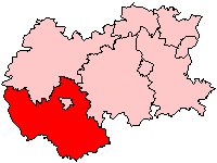
South Herefordshire
Utseende
| South Herefordshire | |
| Före detta distrikt | |
| Land | |
|---|---|
| Riksdel | England |
| Grevskap | Herefordshire |
| Enhetskommun | Herefordshire |
| Koordinater | 51°54′50″N 2°35′01″V / 51.913935°N 2.5836950°V |
| Ross-on-Wye | |
| Area | 904,58 km² |
| Folkmängd | 52 900 (1992) |
| Befolkningstäthet | 58 invånare/km² |
| Tidszon | UTC (UTC+0) |
| - sommartid | BST (UTC+1) |
|
Läge i Storbritannien
| |
South Herefordshire var ett distrikt i Hereford and Worcester i England. Distriktet hade 52 900 invånare år 1992. Distriktet upprättades den 1 april 1974 genom att stadsdistriktet Ross-on-Wye slogs ihop med landsdistrikten Dore and Bredwardine, Hereford och Ross and Whitchurch.[1] Det avskaffades 1 april 1998 och blev en del av Herefordshire.[2]
Referenser
[redigera | redigera wikitext]- ^ ”The English Non-metropolitan Districts (Definition) Order 1972”. legislation.gov.uk. https://www.legislation.gov.uk/uksi/1972/2039/schedule/part/18/made. Läst 23 juni 2022.
- ^ ”The Hereford and Worcester (Structural, Boundary and Electoral Changes) Order 1996”. legislation.gov.uk. https://www.legislation.gov.uk/uksi/1996/1867/made. Läst 23 juni 2022.
Externa länkar
[redigera | redigera wikitext] Wikimedia Commons har media som rör South Herefordshire.


