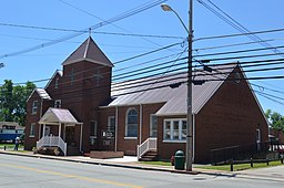
Salyersville
Utseende
| Salyersville | |
| city | |
Prater Memorial United Methodist Church
| |
| Land | |
|---|---|
| Delstat | Kentucky |
| County | Magoffin County |
| Höjdläge | 260 m ö.h. |
| Koordinater | 37°44′53″N 83°3′47″V / 37.74806°N 83.06306°V |
| Yta | 5,5 km² (2010) |
| - land | 5,5 km² |
| - vatten | 0,0 km² |
| Folkmängd | 1 883 (2010) |
| Befolkningstäthet | 342 invånare/km² |
| Tidszon | EST (UTC-5) |
| - sommartid | EDT (UTC-4) |
| ZIP-kod | 41465 |
| FIPS | 2168232 |
| Geonames | 4307447 |
|
Ortens läge i Kentucky
| |
|
Kentuckys läge i USA
| |
Salyersville är administrativ huvudort i Magoffin County i Kentucky.[1][2] Det ursprungliga samhället kallades Prather's Fort efter en av bosättarna eller Licking Station. Postkontoret kallades först Burning Spring, sedan Licking Station. Orten bytte senare namn från Licking Station till Adamsville efter William Adams och slutligen till Salyersville efter Samuel Salyer.[3] Enligt 2010 års folkräkning hade Salyersville 1 883 invånare.[4]
Kända personer från Salyersville
[redigera | redigera wikitext]- Rebecca Lynn Howard, musiker
Källor
[redigera | redigera wikitext]- ^ Kentucky County Map with County Seat Cities. Geology.com Geoscience News and Information. Läst 16 augusti 2016.
- ^ Profile for Salyersville, Kentucky Arkiverad 13 september 2016 hämtat från the Wayback Machine.. ePodunk. Läst 16 augusti 2016.
- ^ Salyersville, Kentucky. Kentucky Atlas & Gazetteer. Läst 16 augusti 2016.
- ^ 2010 Census Population of Salyersville, Kentucky Arkiverad 26 augusti 2016 hämtat från the Wayback Machine.. Census Viewer. Läst 16 augusti 2016.
Externa länkar
[redigera | redigera wikitext]
|


