Renfrewshire
Utseende
| Renfrewshire | ||
| Kommun | ||
|
|
||
| Land | ||
|---|---|---|
| Riksdel | Skottland | |
| Administrativ huvudort |
Paisley | |
| Yta | 261 km²[1] | |
| Folkmängd | 184 340 (2022)[2] | |
| Befolkningstäthet | 706 invånare/km² | |
| Tidszon | GMT (UTC+0) | |
| - sommartid | BST (UTC+1) | |
| ISO 3166-2-kod | GB-FRW | |
| GSS-kod | S12000038 | |
| Geonames | 2639494 | |

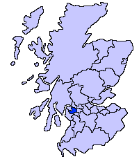
Renfrewshire är en av Skottlands kommuner. Kommunen gränsar till North Ayrshire, East Renfrewshire, Glasgow, Inverclyde och West Dunbartonshire. Centralort är Paisley.
Det traditionella grevskapet och ståthållarskapet Renfrewshire täcker förutom kommunen Renfrewshire även kommunerna East Renfrewshire och Inverclyde, samt några orter i City of Glasgow.
Mellan 1975 och 1996 täcktes området av distriktet Renfrew, som omfattade ett något större område. Då regionen Strathclyde löstes upp 1996 blev Barrhead, Neilston och Uplawmoor överfört till den nya kommunen East Renfrewshire.
Orter
[redigera | redigera wikitext]- Bishopton
- Bridge of Weir
- Brookfield
- Craigends
- Crosslee
- Elderslie
- Erskine
- Houston
- Howwood
- Inchinnan
- Johnstone
- Kilbarchan
- Linwood
- Lochwinnoch
- Paisley
- Ralston
- Ranfurly
- Renfrew
Källor
[redigera | redigera wikitext]- ^ ”Estimates of the population for the UK, England, Wales, Scotland, and Northern Ireland (Mid-2022)” (på engelska) (xls). Landyta, avrundad till hela km². Office for National Statistics. 26 mars 2024. https://www.ons.gov.uk/peoplepopulationandcommunity/populationandmigration/populationestimates/datasets/populationestimatesforukenglandandwalesscotlandandnorthernireland. Läst 25 juni 2024.
- ^ ”Estimates of the population for the UK, England, Wales, Scotland, and Northern Ireland (Mid-2022)” (på engelska) (xls). Office for National Statistics. 26 mars 2024. https://www.ons.gov.uk/peoplepopulationandcommunity/populationandmigration/populationestimates/datasets/populationestimatesforukenglandandwalesscotlandandnorthernireland. Läst 25 juni 2024.


