Leitchfield
Utseende
| Leitchfield | |
| City | |
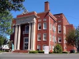
Grayson County courthouse i Leitchfield
| |
| Land | |
|---|---|
| Delstat | |
| County | Grayson County |
| Höjdläge | 227 m ö.h. |
| Koordinater | 37°29′1″N 86°17′38″V / 37.48361°N 86.29389°V |
| Area | 22,8 km² |
| - land | 22,7 km² (100%) |
| - vatten | 0,1 km² (0%) |
| Folkmängd | 6 699 (2010)[1] |
| Befolkningstäthet | 295 invånare/km² |
| Grundad | 1866 |
| Tidszon | CST (UTC-6) |
| - sommartid | CDT (UTC-5) |
| Postnummer | 42726, 42754, 42755 |
| Riktnummer | 270 & 364 |
| FIPS-kod | 21-44686 |
| GNIS-kod | 0496280 |
| Geonames | 4297882 |
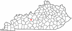
 Leitchfields läge i Kentucky.
| |
| Wikimedia Commons: Leitchfield, Kentucky | |
Leitchfield är en stad (city) och administrativ huvudort (county seat) i Grayson County i delstaten Kentucky, USA. 2010 hade staden 6 699 invånare.[1]
Referenser
[redigera | redigera wikitext]- ^ [a b] ”American FactFinder” (på engelska). United States Census Bureau. Arkiverad från originalet den 12 februari 2020. https://archive.today/20200212234526/http://factfinder.census.gov/faces/nav/jsf/pages/community_facts.xhtml. Läst 19 juli 2015.

