
Isola, Alpes-Maritimes
| Isola | |
| Kommun | |
 | |
| Land | |
|---|---|
| Region | Provence-Alpes-Côte d'Azur |
| Departement | |
| Arrondissement | Nice |
| Kanton | Saint-Étienne-de-Tinée |
| Koordinater | 44°11′N 7°3′Ö / 44.183°N 7.050°Ö |
| Yta | 97,98 km²[1] |
| Folkmängd | 652 ()[2] |
| Befolkningstäthet | 7 invånare/km² |
| Borgmästare | Mylène Agnelli (2020–)[3] |
| Tidszon | CET (UTC+1) |
| - sommartid | CEST (UTC+2) |
| Postnummer | 06420 |
| INSEE | 06073 |
| Geonames | 6446715 |
| OSM-karta | 174229 |
 Kommunens läge i regionen Provence-Alpes-Côte d'Azur i Frankrike.
| |
| Webbplats: https://www.mairieisola.com | |

Isola är en kommun i departementet Alpes-Maritimes i regionen Provence-Alpes-Côte d'Azur i sydöstra Frankrike. Kommunen ligger i kantonen Saint-Étienne-de-Tinée som ligger i arrondissementet Nice. År 2022 hade Isola 652 invånare.
Befolkningsutveckling
[redigera | redigera wikitext]Antalet invånare i kommunen Isola

Galleri
[redigera | redigera wikitext]-

-

-
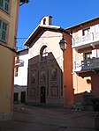 Kapellet Sainte-Anne


Se även
[redigera | redigera wikitext]Källor
[redigera | redigera wikitext]- ^ Répertoire géographique des communes, Institut national de l'information géographique et forestière, läst: 26 oktober 2015.[källa från Wikidata]
- ^ Populations légales 2022, Institut National de la Statistique et des Études Économiques, 19 december 2024.[källa från Wikidata]
- ^ Répertoire national des élus du 2 décembre 2020, 2 december 2020.[källa från Wikidata]
- ^ Chiffres clés - Évolution et structure de la population Arkiverad 5 juli 2012 hämtat från the Wayback Machine.