Greenville, Georgia
Utseende
| Greenville | |
| city | |
| Land | |
|---|---|
| Delstat | Georgia |
| County | Meriwether County |
| Höjdläge | 265 m ö.h. |
| Koordinater | 33°1′40″N 84°42′49″V / 33.02778°N 84.71361°V |
| Yta | 4,7 km² (2010) |
| - land | 4,7 km² |
| - vatten | 0,0 km² |
| Folkmängd | 876 (2010) |
| Befolkningstäthet | 186 invånare/km² |
| Tidszon | EST (UTC-5) |
| - sommartid | EDT (UTC-4) |
| ZIP-kod | 30222 |
| FIPS | 1335016 |
| Geonames | 4198218 |
|
Ortens läge i Georgia
| |
|
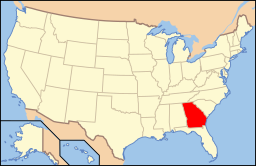
Georgias läge i USA
| |
| Webbplats: http://www.cityofgreenvillega.com/ | |
Greenville är administrativ huvudort i Meriwether County i Georgia.[1][2] Greenville grundades år 1827 som countyhuvudort och fick sitt namn efter militären Nathanael Greene.[3] Enligt 2010 års folkräkning hade Greenville 876 invånare.[4]
Kända personer från Greenville
[redigera | redigera wikitext]- William J. Samford, politiker
Källor
[redigera | redigera wikitext]- ^ Georgia County Map with County Seat Cities. Geology.com Geoscience News and Information. Läst 11 juni 2016.
- ^ Profile for Greenville, Georgia Arkiverad 11 augusti 2016 hämtat från the Wayback Machine.. ePodunk. Läst 11 juni 2016.
- ^ Paul T. Hellmann, Historical Gazetteer of the United States, s. 232. ISBN 0-415-93948-8
- ^ 2010 Census Population of Greenville, Georgia Arkiverad 8 augusti 2016 hämtat från the Wayback Machine.. Census Viewer. Läst 11 juni 2016.


