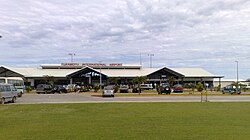
Fua'amotos internationella flygplats
Utseende
| Fua'amotos internationella flygplats | |||||||||||||||
 Fua'amotos internationella flygplats | |||||||||||||||
|
| |||||||||||||||
| Allmän information | |||||||||||||||
|---|---|---|---|---|---|---|---|---|---|---|---|---|---|---|---|
| Ort | Tongatapu | ||||||||||||||
| Land | |||||||||||||||
| IATA-kod | TBU | ||||||||||||||
| ICAO-kod | NFTF | ||||||||||||||
| Öppningsår | 1942 | ||||||||||||||
| Höjd över havet | 38 m | ||||||||||||||
| Koordinater | 21°14′28″S 175°8′58″V / 21.24111°S 175.14944°V | ||||||||||||||
| Banor | |||||||||||||||
| |||||||||||||||
Fua'amotos internationella flygplats (IATA: TBU, ICAO: NFTF) är en flygplats belägen 35 kilometer ifrån Nuku'alofa, Tongas huvudstad, på Tongatapuöarna.[1]
Referenser
[redigera | redigera wikitext]- ^ ”World Areo Data”. Arkiverad från originalet den 6 oktober 2012. https://web.archive.org/web/20121006010834/http://worldaerodata.com/wad.cgi?id=TN79772&sch=NFTF. Läst 29 januari 2012.
Externa länkar
[redigera | redigera wikitext] Wikimedia Commons har media som rör Fua'amotos internationella flygplats.

