Bloomfield, Indiana
Utseende
| Bloomfield | |
| town | |
| Land | |
|---|---|
| Delstat | Indiana |
| County | Greene County |
| Höjdläge | 185 m ö.h. |
| Koordinater | 39°1′29″N 86°56′25″V / 39.02472°N 86.94028°V |
| Yta | 3,6 km² (2010) |
| - land | 3,6 km² |
| - vatten | 0,0 km² |
| Folkmängd | 2 405 (2010) |
| Befolkningstäthet | 668 invånare/km² |
| Tidszon | EST (UTC-5) |
| - sommartid | EDT (UTC-4) |
| ZIP-kod | 47424 |
| FIPS | 1805716 |
| Geonames | 4254671 |
|
Ortens läge i Indiana
| |
|
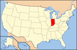
Indianas läge i USA
| |
| Webbplats: http://www.bloomfieldin.com/ | |
Bloomfield är administrativ huvudort i Greene County i Indiana. Orten fick sitt namn efter Bloomfield i New Jersey.[1] Countyt grundades år 1821 och den första huvudorten hette Burlington. År 1824 planlades Bloomfield som ny huvudort.[2]
Kända personer från Bloomfield
[redigera | redigera wikitext]- Gerald W. Landis, politiker
Källor
[redigera | redigera wikitext]- ^ Profile for Bloomfield, Indiana. ePodunk. Läst 26 april 2016.
- ^ Greene County, Indiana History. Genealogy Trails. Läst 26 april 2016.
|


