Berwick-upon-Tweed (distrikt)
Utseende
| Berwick-upon-Tweed | |
| Före detta distrikt | |
| Land | |
|---|---|
| Riksdel | England |
| Region | Nordöstra England |
| Enhetskommun | Northumberland |
| Ceremoniellt grevskap | Northumberland |
| Folkmängd | 25 949 (2001) |
| Tidszon | UTC (UTC+0) |
| - sommartid | BST (UTC+1) |
|
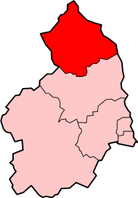
Läge i Northumberland
| |
Berwick-upon-Tweed var ett distrikt i Northumberland i England. Distriktet har 25 949 invånare (2001).[1]
Distriktet bildades den 1 april 1974. Det avskaffades 1 april 2009 då alla distrikt i Northumberland ersattes av en enhetskommun (unitary authority).
Civil parishes
[redigera | redigera wikitext]- Adderstone with Lucker, Akeld, Ancroft, Bamburgh, Beadnell, Belford, Bewick, Bowsden, Branxton, Carham, Chatton, Chillingham, Cornhill-on-Tweed, Doddington, Duddo, Earle, Easington, Ellingham, Ewart, Ford, Holy Island, Horncliffe, Ilderton, Ingram, Kilham, Kirknewton, Kyloe, Lilburn, Lowick, Middleton, Milfield, Norham, North Sunderland, Ord, Roddam, Shoreswood och Wooler.[2]
Referenser
[redigera | redigera wikitext]- ^ ONS. ”Area: Berwick-upon-Tweed (Former Local Authority)”. Neighbourhood statistics. http://neighbourhood.statistics.gov.uk/dissemination/LeadKeyFigures.do?a=7&b=277063&c=Berwick-upon-Tweed&d=13&e=15&g=474329&i=1001x1003x1032x1004&m=0&r=1&s=1475585658547&enc=1. Läst 4 oktober 2016.
- ^ ”Area selected: Berwick-upon-Tweed (Non-Metropolitan District)”. Neighbourhood statistics. Arkiverad från originalet den 4 mars 2016. https://web.archive.org/web/20160304201542/http://www.neighbourhood.statistics.gov.uk/dissemination/viewFullDataset.do?instanceSelection=03070&productId=779&$ph=60_61&datasetInstanceId=3070&startColumn=1&numberOfColumns=4&containerAreaId=790477. Läst 4 oktober 2016.


