
Fil:Noord-Holland position.svg

Storleken för denna PNG-förhandsvisning av denna SVG-fil: 200 × 236 pixlar. Andra upplösningar: 203 × 240 pixlar | 407 × 480 pixlar | 651 × 768 pixlar | 868 × 1 024 pixlar | 1 736 × 2 048 pixlar.
Originalfil (SVG-fil, standardstorlek: 200 × 236 pixlar, filstorlek: 158 kbyte)
| Denna fil tillhandahålls av Wikimedia Commons. Informationen nedan är kopierad från dess filbeskrivningssida. |
Sammanfattning
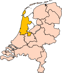
| Beskrivning | Location of the province of Noord-Holland (North Holland) in the Netherlands. |
| Datum | |
| Källa | Own work, based on freely available GIS data |
| Skapare | User:Mtcv |
| Tillstånd (Återanvändning av denna fil) |
Data: attribution required; my work: PD |
| Andra versioner | I attempted to make an svg version of Image:Noord Holland-Position.png (with less simplified boundaries) |
Clickable version

Licensiering

|
Upphovsrättsinnehavaren till denna fil, Centraal Bureau voor de Statistiek, tillåter vem som helst att använda den i valfritt syfte, förutsatt att lämplig hänvisning till upphovsrättsinnehavaren ges.
Vidaredistribution, redigering av verk, kommersiell användning och all övrig användning är tillåten. |
Erkännande:
|
| Annotations | This image is annotated: View the annotations at Commons |


Filhistorik
Klicka på ett datum/klockslag för att se filen som den såg ut då.
| Datum/Tid | Miniatyrbild | Dimensioner | Användare | Kommentar | |
|---|---|---|---|---|---|
| nuvarande | 2 mars 2019 kl. 18.20 | | 200 × 236 (158 kbyte) | Thayts | update |
| 2 oktober 2006 kl. 16.13 |  | 200 × 236 (158 kbyte) | Mtcv | {{Information| |Description=Location of the province of Noord-Holland (North Holland) in the Netherlands. |Source=Own work, based on freely available GIS data |Date=2006-10-02 |Author=User:Mtcv |Permission=Data: attribution required; my work: PD |othe |
Filanvändning
Inga sidor använder den här filen.
Global filanvändning
Följande andra wikier använder denna fil:
- Användande på ar.wikipedia.org
- أمستردام
- شمال-هولندا
- هلفرسوم
- ألكمار
- هارلم (شمال-هولندا)
- زانستاد
- هارلمرمير
- قالب:بلديات شمال هولندا
- سخاخن
- دن هيلدر
- فيلسن
- زانتفورت
- بلوميندال
- ألسمير
- لاندسمير
- أوستزان
- تيسل
- أمستلفين
- إنكهاوزن
- هورن (هولندا)
- فاترلاند
- بيمستر
- بيفيرفايك
- بيرخن (شمال هولندا)
- بلاريكوم
- هيمستيده
- بوابة:أمستردام/قوالب
- بوابة:أمستردام
- حكومة أمستردام
- هارلمرليده آن سبارنفاودا
- آودر- أمستل
- ديمين
- فيسب (هولندا)
- كاستركوم
- دريخترلاند
- إدام- فولندام
- هيمسكيرك
- هيرهوخوفارد
- هيلو (هولندا)
- هولاندز كرون
- هاوزن
- كوخينلاند
- لانجادايك
- لارين (هولندا)
- ميديمبليك
- أوبمير
- بورميراند
- ستيده بروك
- آوتخيست
- آوتهورن
Visa mer globalt användande av denna fil.