
Fil:East Wallabi Island.jpg

Storlek på förhandsvisningen: 730 × 600 pixlar. Andra upplösningar: 292 × 240 pixlar | 584 × 480 pixlar | 935 × 768 pixlar | 1 111 × 913 pixlar.
Originalfil (1 111 × 913 pixlar, filstorlek: 51 kbyte, MIME-typ: image/jpeg)
| Denna fil tillhandahålls av Wikimedia Commons. Informationen nedan är kopierad från dess filbeskrivningssida. |
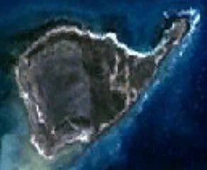
| Beskrivning | This is a satellite image of East Wallabi Island in the Houtman Abrolhos. | |||
| Datum | Created on 2007-11-21; not sure when the satellite image was collected. | |||
| Källa | It was made with NASA World Wind using Landsat 7 data. | |||
| Skapare | It was created by Hesperian. Any IP involved in the creation of this image is released into the public domain. | |||
| Tillstånd (Återanvändning av denna fil) |
|

Filhistorik
Klicka på ett datum/klockslag för att se filen som den såg ut då.
| Datum/Tid | Miniatyrbild | Dimensioner | Användare | Kommentar | |
|---|---|---|---|---|---|
| nuvarande | 21 november 2007 kl. 13.40 | | 1 111 × 913 (51 kbyte) | Hesperian | {{Information |Description=This is a satellite image of East Wallabi Island in the Houtman Abrolhos. |Source=It was made with NASA World Wind using Landsat 7 data. |Date=Created on 2007-11-21; not sure when the satellite image was collected. |Aut |
Filanvändning
Följande sida använder den här filen:
Global filanvändning
Följande andra wikier använder denna fil:
- Användande på arz.wikipedia.org
- Användande på ceb.wikipedia.org
- Användande på en.wikipedia.org
- Användande på it.wikipedia.org
- Användande på www.wikidata.org