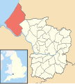
Fil:Avonmouth Bristol UK ward map.svg
Utseende

Storleken för denna PNG-förhandsvisning av denna SVG-fil: 539 × 600 pixlar. Andra upplösningar: 216 × 240 pixlar | 431 × 480 pixlar | 690 × 768 pixlar | 920 × 1 024 pixlar | 1 841 × 2 048 pixlar | 1 138 × 1 266 pixlar.
Originalfil (SVG-fil, standardstorlek: 1 138 × 1 266 pixlar, filstorlek: 709 kbyte)
Filhistorik
Klicka på ett datum/klockslag för att se filen som den såg ut då.
| Datum/Tid | Miniatyrbild | Dimensioner | Användare | Kommentar | |
|---|---|---|---|---|---|
| nuvarande | 28 september 2010 kl. 14.20 |  | 1 138 × 1 266 (709 kbyte) | Nilfanion | {{Information |Description=Map of Avonmouth electoral ward in Bristol, UK. Boundaries are correct as of May 2010. Equirectangular map projection on WGS 84 datum, with N/S stretched 160% Geographic limits: *West: 2.73W *East: 2.5W *North: 51.55N *South: |
Filanvändning
Följande sida använder den här filen:
